


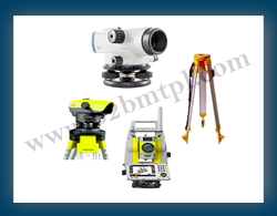
We BB Marketing Technologies Pvt.Ltd. are Manufacturers, Suppliers, Provider, Dealer, Exporters of Survey Instrument.Land survey instruments are tools used by surveyors to measure and map the Earth's surface features, including land boundaries, topography, and man-made structures. These instruments are essential for accurately determining positions, distances, and angles in land surveying and mapping projects.Modern land survey instruments, such as total stations and GPS/GNSS receivers, provide high levels of accuracy in measuring distances, angles, and elevations. This accuracy is crucial for ensuring precise alignment, grading, and positioning of structures and infrastructure elements.Land survey instruments allow for rapid data collection and processing, significantly reducing the time required for surveying tasks compared to traditional methods. This increased efficiency enables projects to progress more quickly, leading to cost savings and shorter project timelines.GPS/GNSS receivers enable remote measurement of points over large areas, reducing the need for physical access to difficult or hazardous terrain. This capability is particularly valuable for surveying expansive areas such as forests, mountains, or water bodies. Land survey instruments can seamlessly integrate with GIS software, allowing survey data to be spatially referenced and analyzed within a geographic context. This integration enhances decision-making processes by providing valuable spatial insights and facilitating data sharing among project stakeholders.Some land survey instruments offer real-time data collection capabilities, allowing surveyors to immediately verify measurements and adjust survey parameters as needed. This real-time feedback improves survey accuracy and efficiency, especially in dynamic field conditions.Survey instruments support the creation of detailed 3D models and visualizations of surveyed terrain, structures, and infrastructure. These models aid in design, planning, and visualization tasks, enabling stakeholders to better understand project requirements and potential impacts.
Land survey instruments are used for monitoring construction progress, verifying adherence to design specifications, and ensuring quality control throughout the construction process. By comparing surveyed data to design plans, surveyors can identify discrepancies and implement corrective measures promptly.Land survey instruments reduce the need for manual measurement methods, minimizing surveyors' exposure to hazardous environments or working conditions. Remote measurement capabilities also enhance safety by eliminating the need to access inaccessible or unsafe areas.While land survey instruments may represent an initial investment, their increased efficiency and accuracy result in long-term cost savings over the duration of a project. Reduced labor costs, faster project completion times, and improved project outcomes contribute to overall cost-effectiveness.Accurate land surveys are often required for regulatory compliance purposes, such as obtaining permits, easements, or property boundaries. Land survey instruments ensure that survey data meets regulatory standards and can withstand legal scrutiny when necessary.Overall, land survey instruments play a critical role in modern construction and development projects, offering numerous advantages in terms of accuracy, efficiency, safety, and cost-effectiveness.We BB Marketing Technologies Pvt.Ltd. are deeply engaged in offering a wide array of Survey Instrument to our valuable Clients located in Mumbai, in Navi Mumbai, in Thane and all over India.


Follow Us